Visualising Spatial History
The maps presented below were produced, predominantly, as research tools rather than final outputs. Building on debates within broader historical discourse, the use of digital tools in presenting these spatial visualisations of the broader suffrage narrative proved exceedingly beneficial for the final analysis.
For one, they allow patterns obscured by more textual sources to be more readily identified and connections between individuals based on space, place and geographic proximity to be analysed. Highlighting the extent to which such tools allow new questions to be asked, explanations to be suggested and conclusions to be drawn, the exercise proved a valuable one.
The data used to produce these spatial visualisations lends them an extra layer of significance. With the material focussing on a fundamentally female-oriented topic, the tools used to conduct the research, and outputs used to present it, provide a critical insight into the female lived-experience of nineteenth-century New Zealand. Allowing women's activism, relationships and geographic connections to speak for themselves, visually through the maps, sheds light on this experience and works to provide a voice for this critical group that has otherwise been left somewhat obscured by more traditional research methods.
Map 1: Signatories in the Broader Picture
One of the primary aims of this research was to assess the geography of political sociability in Napier during the 1893 suffrage campaign. Mapping political activism, and consequentially privileging the influence of geographic space as a point of inquiry, has not previously been attempted in this context.
Click image to view interactive map in new window.
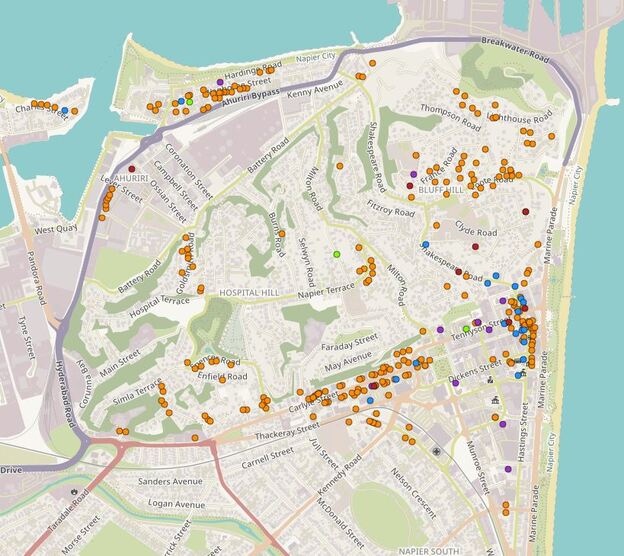
Interpretation
Providing a broad societal picture, this mapping exercise works to highlight the significance of several key institutions. Clusters of signatories around the hotels in southern Napier, particularly along Carlyle Street, indicate that the salience of alcohol consumption - hotels being primary licenced venues - may have influenced engagement with the WCTU temperance agenda and, by extension, the suffrage campaign more broadly.
Likewise, clustering around Port Ahuriri highlights the potential significance of both Port Ahuriri Presbyterian Church and Harriet Cobb's photographic studio. The cluster of women around the Hawke's Bay Children's Home is also significant. Alluding to the prominence of that institution within Napier of the 1890s, and the political association between women of the Napier Women's Franchise League and the Home itself.
The map itself has proven useful as a research tool for the connections it has illuminated. It has also served as a critique of the overall sampling methodology. By visualising the sample of signatories, it was easier to identify areas of conspicuous absence. Milton Road, for example, contributed very few signatories to the present analysis. This was largely because sheet 427, which contained many Milton-signatories, was not included in the present sample. Many of the women of Carlyle Street, by comparison, signed sheet 437, which was included, and thus appear in the present analysis.
Visualising the data spatially allowed biases in the sampling methodology to be identified, facilitating a more critical research process which appreciated the extent to which the sampling methodology influenced the overall outcome. An absence of evidence could not necessarily be equated with evidence of lack of engagement. The visualisation exercise, then, made for a more self-conscious research methodology overall.
Map 2: Geography of Signature Soliciting
In addition to placing the signatories themselves in the broader picture of 1890s Napier, mapping of this nature provides an opportunity to examine the patterns of signature soliciting more closely. The map below depicts the residences of signatories from ten Napier petition sheets. Signatories are grouped by sheet, and appear in coloured groups as such.
Click image to view interactive map in new window.
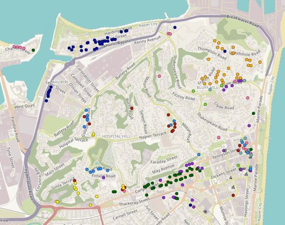
Interpretation
Mapping these signatories by sheet allowed the canvassing methods employed by the local Women's Franchise League and WCTU branch to be identified. Explicit evidence of the utilisation of these political methods at the local level has not previously been demonstrated in this context. The mapping techniques employed here, then, contribute much to our understanding of the broader suffrage movement in Hawke's Bay.
Soliciting support for the cause, the dispersal of signatures displayed in the map above highlights the diversity of approaches utilised by the local suffrage activists. The close geographic focus of sheets 426 and 437, appearing in orange and dark green, for example, allude to the use of door to door canvassing.
Systematic street canvassing was employed by WCTU branches across the country, dramatically politicising public space. The street was thus transformed into a more salient site of political activism. Bringing participation direct to the doorstep, suffrage canvassers, generating a political contact zone, the family home became another prominent site of engagement at a previously unprecedented level.
The importance of community connectedness can also be illustrated. With several sheets containing signatures which were far more dispersed geographically, it is clear that suffragists involved in the Napier campaign utilised public meetings and street corner collections as a means of obtaining signatures as well. The prominence of the suffrage agenda in public space is thus underlined, and the political nature of life in 1890s Napier successfully emphasised.
Map 3: National Mobility
Questions of mobility arose in light of challenges encountered in tracing some individuals onto the 1893 and 1896 electoral rolls. Unable to locate some signatories on the Napier roll, I turned to wider national rolls. Several signatories were found to have moved out of Napier, some beyond Hawke's Bay entirely, between 1893 and 1896. The map below illustrates some of these patterns, providing an insight into the extent and impact of colonial mobility.
Signatories addresses have been mapped according to information obtained from the 1893 petition (purple), 1893 electoral roll (green), and 1896 electoral roll (white) allowing for a rough assessment of geographic dispersal and change over time. This process has also allowed for the identification of some key individuals as useful points of inquiry. The movement of Mrs Ella Stuart Dick, who was residing in Wellington by 1896, is one case which will be discussed further in the final research.
Signatories addresses have been mapped according to information obtained from the 1893 petition (purple), 1893 electoral roll (green), and 1896 electoral roll (white) allowing for a rough assessment of geographic dispersal and change over time. This process has also allowed for the identification of some key individuals as useful points of inquiry. The movement of Mrs Ella Stuart Dick, who was residing in Wellington by 1896, is one case which will be discussed further in the final research.
Best viewed in google maps. Access using the full-screen icon in top right corner.
Interpretation
The extent to which signatories dispersed beyond Hawke's Bay between 1893 and 1896 is significant. This map works to illustrate this pattern and simultaneously highlights the extent to which such mobility within the colonial context was both possible and influential. Napier served as a prominent transport hub for wider Hawke's Bay, with a rail connection to Wellington which had been completed in 1891 and a working port.
The subsequent increase in accessibility significantly shaped the local suffrage campaign in many ways. For one, it enabled Napier to serve as host for the eighth annual conference of the WCTU in March 1893, increasing the salience of the suffrage question in local discourse, and identifying Napier as a sight of activism worthy of national recognition.
The mapping exercise also illustrates the benefit of the sources utilised in the present analysis in providing an insight into mobility from a female perspective. Such a narrative is difficult to compile, given the patriarchal nature of colonial New Zealand society and subsequent bias in the written archive toward male experience. Women are all too frequently obscured by the traces of more dominant men with whom they were associated. Tracing the women themselves proved both challenging and necessary for this reason. The map then stands as a critical example of the extent to which the use of digital tools in historical research can work to provide a voice for those silenced by more traditional historical methods.
Header Credit: Ian Blackburn, 2019.
