|
Back in 2008, Anne Knowles and Amy Hillier declared that historical Geographic Information Systems (GIS) were 'still something of a maverick method in the study of history.' In recent years, however, such tools have been utilised by scholars from a number of disciplines, and we are seeing an increasing trend towards their adoption in the humanities. Most readily identifiable, as a contemporary example of spatial historical scholarship, is the Stanford Spatial History Project. Other exciting projects like the Venice Time Machine have also highlighted the benefits of combining geographic analysis and mapping techniques with archival sources as a means of mapping social networks. As the data already compiled for the present study provided a starting point for geographic analysis, it seemed only appropriate to attempt to apply some of these digital methods to the suffrage activists of Napier. Ambiguity of the PetitionIn signing the petition in 1893 the suffrage signatories provided two crucial pieces of information. The first, their name, provides us with a clear statement of individual engagement. A clear marker of identification, the names used by signatories have been used as a crucial means of tracing individuals onto other documents and fleshing out the detail of individual stories behind the 30'000 strong statement of political agency. Work by the Ministry for Culture and Heritage and the curators and archivists from He Tohu, has seen a number of biographies crowdsourced from interested members of the public. Signatories also provided a second critical piece of identifying information: their address. Studies which have assessed the suffrage signatories as individuals have tended to focus, with good reason, on the names. In such cases, geographic location has been relegated to the sphere of useful secondary information. A means of pinning down more personal detail rather than a point of interest in itself. In many cases, address has been neglected in favour of the more dynamic, identifiably personal, nominal signifier provided by each signatory. Initial attempts to map patterns of suffrage activism using the data obtained from the 1893 petition and 1893 and 1896 electoral rolls proved somewhat challenging. This difficulty stemmed, predominantly, from the idiosyncrasies of the petition itself. Signatories did not sign in any standardised form, a fact which I have previously rued somewhat in my partially successful attempts to trace the 540-strong sample onto any form of supporting documentation. Names were one source of difficulty. It would seem reasonable to expect addresses to prove less of an issue, geographic location appearing to occupy a more concrete position than personal identification preference. However, I soon realised that just one woman of my 540 signatories, Mrs Tilly Kessel of 1 Byron Street, had provided a precise address. Many of the remaining 539 had simply provided a street, with 'Carlyle Street' emerging as a fairly well represented locality, or a suburb. Still more had felt no need to go into further detail than to position themselves within 'Napier' or 'Hastings'. It appeared, from a brief analysis of the sheets, that signatories had tended to follow the structure used by the first woman on the sheet. As such, I was left faced with entire sheets, sheet 442 for example, with line after line of the suitably ambiguous 'Napier' in the address column. Broader ActivismI decided to map the data anyway. Using Google Maps, taking street names as the point of reference, and marking a single point for each street with signatory representatives in the sample. This method was effective in some respects. It is possible, for example, to see that signatories were fairly well dispersed throughout urban Napier. Zooming out, some 'out-of-zone' signatures could also be identified, with Sarah Collins and Annie E. Tennyton-Smith representing Palmerston North and Wellington respectively. 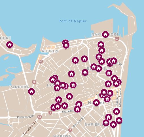 1893 Signatories by Street In cases where individuals had been successfully traced onto the electoral rolls, I had some more precise address information, at least to the street level in most cases, for a larger proportion. I decided, then, to also map the streets represented on the 1893 and 1896 electoral rolls. This exercise proved interesting, allowing for some assessment of mobility across the three year period. It was possible, for example, to more easily identify cases where women had moved away from Napier between 1893 and 1896. Lizzie Molloy, for example, who was residing in Nelson by 1896 having followed her husband Patrick in his new position as warden of Nelson gaol.  1893 and 1896 Addresses of Signatories by Street On the whole, however, this method did prove problematic. The lack of scale was one identifiable concern. With no exact addresses, and streets having to stand as proxy for various individuals, it was difficult to assess the significance of particular areas. Carlyle Street, for example, contributed at least 61 signatories to the final sample of 540. Using this mapping method, however, it appeared just as significant, at least in visual terms, as Byron Street (where Mrs Kessel was one of two representatives). I had hoped to be in a position to use the mapping exercise to shed some light on the potential significance of various social structures and to identify patterns of signature soliciting and active engagement. In order to do so, I required more precise addresses for individual signatories. Sheet-Based ActivismFor this reason, among others, I turned to Stones' street directories for 1894-95. This proved somewhat successful. At present, I have been able to pinpoint 246 of the 540 women in the sample, using the New Zealand Birth, Death, and Marriage indexes as a means of triangulating any inferences re relationships to head of household. Signatories from some sheets proved easier to trace than others. Sheet 440, for example, contained a number of signatures from a fairly condensed area in Port Ahuriri, many on a single street, and more than two thirds of them were identified in the street directory. Mapping the sheets individually, using the same method outlined above but now in a position to utilise a single data point for each signatory successfully located, provided a means of better understanding the spatial nature of a number of sheets.  1893 Signatories by Petition Sheet I combined this data with further information on the location of social, political, and religious regions of significance, also obtained from the street directory. Mapping hotels and religious institutions proved particularly beneficial, allowing some sites to be identified as potentially influential. Knox Presbyterian Church in Port Ahuriri, close to which the blue sheet 440 signatories in the top left corner appear to cluster. This method also worked to further solidify the significance of some key individuals. Emily Hill, President of the Napier Women's Franchise League, being one of them. Located under her husband Henry's name, she was living on Elizabeth Road in Bluff Hill in 1893. She signed sheet 426, the first Napier sheet to appear in the national petition, and the remainder of signatories who have been tracked thus far are all within a 700m radius of her residence. Compare this pattern with some of the other, more geographically dispersed, sheets and it is clear that suffrage activists in Napier, like those elsewhere in New Zealand, were utilising a range of canvassing techniques in their search for signatures. Clearly, such trends would be harder to identify on paper than in their visualised form. It is particularly beneficial to be able to layer the spatial networks of particular sheets on top of one another as a means of identifying trends and areas of significance. Just as clearly, the method utilised here is not without its pitfalls. If no longer something of a 'maverick method,' this exercise has really served to highlight the complexities of visualising historical data spatially, even in cases where such an endeavour would appear to be fairly straightforward. Sources and Further Reading
Anne Kelly Knowles (ed.), Placing History: How Maps, Spatial Data, and GIS Are Changing Historical Scholarship, (Redlands: ESRI, 2008). Alexander von Lunen and Charles Travis (eds.), History and GIS: Epistemologies, Considerations and Reflections, (London: Springer, 2013). Richard White, 'What is Spatial History?', Spatial History Lab, 1 February 2010, accessible: https://web.stanford.edu/group/spatialhistory/cgi-bin/site/pub.php?id=29
0 Comments
Leave a Reply. |
 RSS Feed
